-
5% dto.
Caracteristicas
- Páginas: 2
- Formato: 19,6x9,5 cm
- Fecha Edición: 2017
- Idioma: Inglés.

- Encuadernación: Tapa blanda o Bolsillo.
-
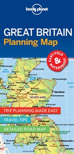
Great Britain Planning Map
-
9781786579058
-
-
-
-
-
-
Durable and waterproof, with a handy slipcase and an easy-fold format, Lonely Planet Great Britain Planning Map is your conveniently-sized passport to traveling with ease. Get more from your map and your trip with images and information about top country attractions, itinerary suggestions, a transport guide, planning information, themed lists and practical travel tips. ? Durable and waterproof.? Easy-fold format and convenient size.? Handy slipcase.? Full colour and easy-to-use.? Before-you-go info.? Beautiful imagery.? Tailored itineraries.? Can?t-miss regional highlights.? Detailed town index.? Transport planner.? Themed lists. Coverage Includes: London, Canterbury, Cambridge, Oxford, Cotswolds, Stratford-Upon-Avon, Stonehenge, Bath, Bristol, Cornwall, York, Lake District, Liverpool, Pembrokeshire, Cardiff, Brecon Beacons, Snowdonia, Edinburgh, Glasgow, Scottish Borders, Skye, Mull, Glen Coe, Northwest Highlands Coast, Scotland?s whisky distilleries. Full Map Dimensions: 63.5 cm x 49.5 cm (25 in. x 19.5 in.)
El libro pertenece a los siguientes catálogos